


Parts of the southwest are bracing for Hurricane Hilary’s potentially devastating impact. The powerful storm is expected to unleash a prolific amount of rainfall across parts of California and the southwestern United States. Experts believe Hurricane Hilary could flood parts of Arizona, California, and Nevada with more than a year’s worth of rain.
Officials have issued a Level 4 of four threat for the areas in South California expected to be impacted. At this time, Hurricane Hilary is expected to impact Tijuana, Oceanside, Los Angeles, Riverside, Barstow, Bakersfield, and the surrounding areas around 6 a.m. Monday.
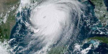
Category 4
 Within 24 hours, Hilary rapidly intensified from a tropical storm to a Category 4 hurricane. Currently, the powerful cyclone has 145 mph winds. Experts project the storm to hold its major hurricane status — wind speed greater than 110 mph — until early Sunday morning. Then it will begin to lose some of its fierceness, with wind speeds dropping between 74 MPH and 110 mph.
Parts of Mexico are currently being berated by the powerful winds and rain that Hurricane Hilary has to offer. U.S. residents in the projected pathway are rushing to set up sand barriers to hopeful deter flooding in their homes and businesses. Many are hopeful the storm will not be too destructive, though it is hard to fully predict.
Furthermore, Hilary’s tempestuous conditions have caused the National Hurricane Center to issue a tropical storm watch from the California-Mexico border to the county lines between Orange and Los Angeles counties. This includes the Catalina Island as well.
Cause and Effect
A high-pressure system has created a heat dome over the central and southeastern part of the U.S. Experts expect the heat dome to bring stiflingly hot temperatures. Additionally, the pressure system and the wind are believed to be influencing Hurricane Hilary’s movements. Normally, tropical cyclones are pushed out western away from California. However, this time, the storm is being drawn into the United States.
Hurricane Hilary is expected to make landfall in Mexico before crossing into California. However, if it decides to hit California directly, it will be the first tropical storm to do so in almost 84 years.
Last night, the hurricane center stated, “The threat of significant wind impacts continues to increase for northern portions of the Baja California Peninsula and the Southwestern United States, especially in areas of mountainous terrain.”
Intense Downpours
Hurricane Hilary may substantially weaken prior to reaching Southern California and parts of the Southwest. However, it is still expected to enhance heavy rainfall and increase flooding danger.
Residents should expect to start seeing heavy rainfall and last through the beginning of next week. Additionally, the forecast is calling for the most intense downpours to occur Sunday into Monday.
During the first few days, it is difficult to pinpoint the exact pathway a hurricane may take. However, after day three or four, it begins to stay on a steady path, making it easier to predict where it is heading.
By Sheena Robertson
Sources:
CNN: Hurricane Hilary could dump over a year’s worth of rain on parts of the Southwest
NBC News: A heat dome and a hurricane
National Hurricane Center: HURRICANE HILARY
Top and Featured Image Courtesy of vanessa‘s Flickr Page – Creative Commons License
Inset Image Courtesy of Karsun Designs‘ Flickr Page – Creative Commons License
