


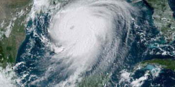


Reports from the NOAA, National Oceanic and Atmospheric Administration, are warning residents and businesses along the Gulf Coast that the 2022 hurricane season could be as destructive as the 2005 season. The water temperatures are already warmer than normal stemming from a condition known as “The Loop Current.”
They are warning states from Texas to Florida that because the Loop Current has already moved farther north than usual, and this season was already expected to be very active, the forecast for stronger and longer-lasting storms is a possibility.
The simple explanation is that when a storm passes over the Loop Current or parts spun off from the main part of the current, they gain power quickly and the force of destructive winds and water content are greatly magnified.
In 2005 the Loop Current was responsible for Hurricane Katrina which devastated New Orleans. There were 27 named hurricanes during the season, seven of which were extremely severe. They included hurricanes Wilma and Rita which were two of the most intense hurricanes on record in the Atlantic.
Hurricanes draw their strength from the top 100 feet of water. This is what is causing deep concern from climate scientists. This could be one of the most dangerous seasons in history.

In mid-May 2022, satellite data showed the Loop Current had water temperatures of 78° F or warmer down to about 330 feet (100 meters). By summer, that heat could extend down to around 500 feet (about 150 meters).
In 2021, Hurricane Ida rushed across water temperatures of 86 degrees Fahrenheit. The heat went down as far as 590 feet. These conditions combined to intensify Ida into a category four storm.
These early conditions are unquestionably the result of climate change. The temperatures of our oceans continue to rise, resulting in ideal conditions for more powerful storms. Greenhouse gasses held in by the atmosphere are stored primarily in the oceans and the reason why the polar ice cap is melting at an alarming rate.
Every study shows that this condition will result in an increase in the number of storms in the Atlantic, and those storms will be more intense than the average.
The NOAA reports that “water temperatures throughout the entire Gulf of Mexico and western Atlantic are running 1 to 3 degrees above average.” The unusually warm water boosts the “potential intensity,” or maximum theoretical strength, a hurricane can achieve.
Denying climate change will not prevent the outcome of changes in the environment. People have been warned for decades, but choose to deny reality although the United States is one of the major producers of pollution resulting from the use of fossil fuels.
One last warning from the most experienced climatologists.
“Stronger hurricanes are expected to become more common as climate change heats up the world’s oceans. Warmer than average sea surface temperatures in the Atlantic Ocean and [the] Caribbean Sea are also likely to boost hurricane activity this season,” NOAA said today.
Written by James Turnage
Edited by Sheena Robertson
Sources:
The Conversation: Bad news for the 2022 hurricane season: The Loop Current, a fueler of monster storms, is looking a lot like it did in 2005, the year of Katrina
DailyKos: There is an ‘800 pound gorilla’ in the Gulf of Mexico that could supercharge the region’s hurricanes
Top and Featured Image Courtesy of Kelly DeLay’s Flickr Page – Creative Commons License
Inset Courtesy of Alan Szalwinski’s Flickr Page – Creative Commons License
